Tropical depression to strengthen into storm, heading toward central Vietnam

VOV.VN - A tropical depression that is swirling over the northern part of the East Sea is likely to strengthen into a storm in the next 24 – to 48 hours, according to the National Centre for Hydro-Meteorological Forecasting.

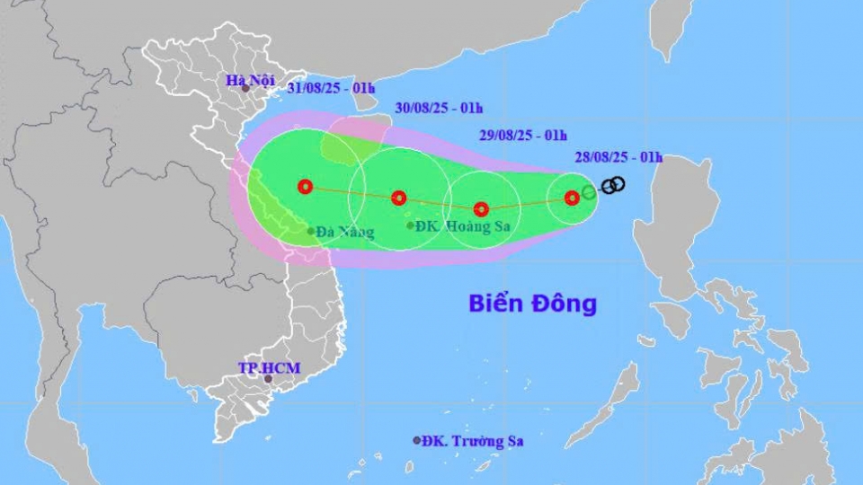
At 1:00 p.m. on August 28, the tropical depression was located in the northern part of the East Sea, about 420 km east-southeast of Vietnam’s Hoang Sa (Spratly) Archipelago. It was packing winds of 39–61kmh, with gusts up to 88kph.
By 1:00 p.m. on August 29, the tropical depression is expected to be over the waters of the Spratly Archipelago, gusting 88kph.
In the next 24 to 36 hours, the tropical depression will continue moving northwestward at around 20kmh and may strengthen into a storm. If it does intensify, it will be the sixth storm of its kind to form in the East Sea this year.
By 1:00 p.m. on August 30, the tropical depression is forecast to be over the waters off the central provinces from Nghe An to Da Nang, with maximum sustained winds of nearly 100kph.
From 48 to 72 hours ahead, the tropical depression will continue moving mainly westward at around 20kmh and gradually weaken.
Due to the influence of the tropical depression, the northern part of the East Sea, including the Spratly Archipelago will experience strong winds, with gusts up to 88kph, and waves of 2–4m high.
Vessels operating in the danger zone are at risk of thunderstorms, squalls, strong winds, and high waves.
From the evening of August 29 to August 30, localities in the northern region will experience heavy rain with thunderstorms, with rainfall commonly ranging from 50–100 mm, and in some places exceeding 200 mm.
Localities from Thanh Hoa to Hue are anticipated to endure a spell of heavy rain, with common rainfall totaling 100–200mm, and even over 350mm in some places.
There is a risk of intense downpours, with rainfall exceeding 150mm within three hours, posing a high risk of flashfloods, landslides, and flooding.
Tropical depression heads toward central Vietnam
VOV.VN - A tropical depression is heading toward central Vietnam, bringing heavy rain to the region in the coming days, according to the National Centre for Hydro-Meteorological Forecasting (NCHMF).


