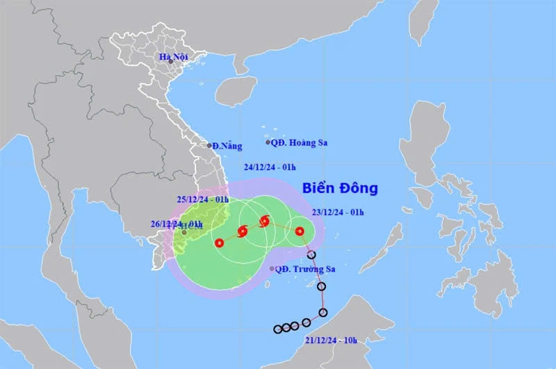
Tropical depression likely to strengthen into a storm
VOV.VN - The tropical depression that formed in the East Sea on December 21 is likely to gain strength into a storm on December 23 evening, with maximum winds reaching 62–74 kmh and gusts of up to 89-102kph, according to the National Center for Hydro-Meteorological Forecasting.

At 1:00 AM on December 23, the tropical depression was churning through the waters near Vietnam’s Spratly Islands, packing winds of 50–61 kmh near its centre.
In the coming 24 hours, the tropical depression is forecast to move west-northwestward at a speed of 5–10 kmh, and potentially develop into a storm.
The storm is projected to move into the southwestern waters of the central part of the East Sea on December 25 and sustain its gusts of 89-102kph.
Between 48 and 72 hours later, the storm is expected to maintain a west-southwestward trajectory at about 10 kmh and gradually weaken into a tropical depression.
While the storm’s intensity decreases, its lingering effects, such as strong winds, heavy rainfall, and rough seas, may still pose risks to affected areas, especially coastal and low-lying regions.
Due to the impact of the tropical depression, localities from Da Nang to Khanh Hoa will experience heavy rain as of December 23 evening, which is expected to persist for several days.
Meanwhile, the southern and Central Highlands regions will also endure scattered rain as of December 24 morning, with rainfall to increase in some areas as the weather system progresses.
Vessels operating in the affected areas are at risk of thunderstorms, strong winds, and high waves.
Residents should be alert for potential flooding, landslides, and other weather-related hazards.


