Tropical depression forms over East Sea as northern Vietnam braces for cold spell

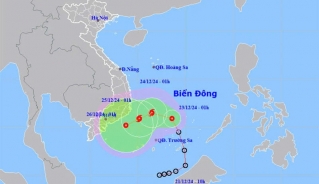
VOV.VN - The National Center for Hydro-Meteorological Forecasting (NCHMF) on February 12 reported that a low-pressure area in the central East Sea had intensified into a tropical depression.

As of 7 a.m., its center was located northwest of the Truong Sa (Spratly) Archipelago, with maximum winds of level 6 (39-49 km/h) and gusts of level 8, moving slowly northwestward at around 5 km/h.
In the next 48 to 72 hours, the tropical depression is expected to continue moving northwestward at a slow pace and gradually weaken. Meteorological authorities have warned of strong showers, thunderstorms, and gusty winds of level 8 over the western central East Sea, the southwestern northern East Sea, and the offshore waters from Phu Yen to Ninh Thuan, with waves reaching 2 - 3.5 meters.
The Ministry of Agriculture and Rural Development has urged coastal provinces from Binh Dinh to Kien Giang to closely monitor the situation, notify fishermen to take precautions, and be prepared for rescue operations if needed.
Meanwhile, a cold spell is moving southward and is expected to affect northeastern Vietnam, north-central Vietnam, and parts of the northwest by the night of February 12 and early February 13. From tomorrow, northern and north-central Vietnam will experience chilly weather, with mountainous areas facing severe cold conditions. Hanoi’s lowest temperatures are expected to range between 15 and 17 degrees Celsius.
The cold air combined with an upper-level westerly trough will bring light rain to northeastern and north-central Vietnam. At sea, strong northeasterly winds of level 5-6, with gusts of level 7-8, will affect the Gulf of Tonkin, while the northern East Sea, including the waters around the Hoang Sa (Paracel) Archipelago, will see waves of 2 - 4.5 meters.
Tropical depression likely to strengthen into a storm
VOV.VN - The tropical depression that formed in the East Sea on December 21 is likely to gain strength into a storm on December 23 evening, with maximum winds reaching 62–74 kmh and gusts of up to 89-102kph, according to the National Center for Hydro-Meteorological Forecasting.
