Tropical depression forms in East Sea, likely to strengthen into storm

VOV.VN - A tropical depression has formed near the East Sea and is forecast to strengthen into a storm in the coming 24 hours, the National Centre for Hydro-Meteorological Forecasting said on July 23.

At 10:00a.m. on July 23, the tropical depression was located over the northwestern waters off Luzon Island of the Philippines, packing maximum sustained winds of between 39–49 kmh. It was moving west-southwest at approximately 15 kmh.
At around 10:00a.m. on July 24, the tropical depression is anticipated to strengthen into a tropical storm and move south-southwest with winds gusting to 102kph near its centre.
Over the next 48 to 72 hours, the storm is expected to continue moving northeast at 20–25 kmh and gradually weaken back into a tropical depression.
Due to the tropical system, the eastern part of the northern East Sea will experience strong winds and rough seas, with wave heights of 2-3.5m.
In a dispatch dated July 23, the Minister of Agriculture and Environment requested that the administrations of coastal provinces and cities from Quang Ninh to Dak Lak, as well as ministries in charge of national defence, public security, construction, industry and trade, foreign affairs, and science and technology, take proactive measures in response to the tropical depression in the East Sea.
The designated agencies and localities were required to closely monitor warnings, forecasts, and developments of the tropical depression; notify owners of vessels operating at sea of the system’s position, movement, and potential risks so they can actively avoid danger areas or evacuate if necessary.
In addition, relevant agencies were instructed to prepare rescue forces and equipment to be ready for deployment in case of emergency search and rescue operations.
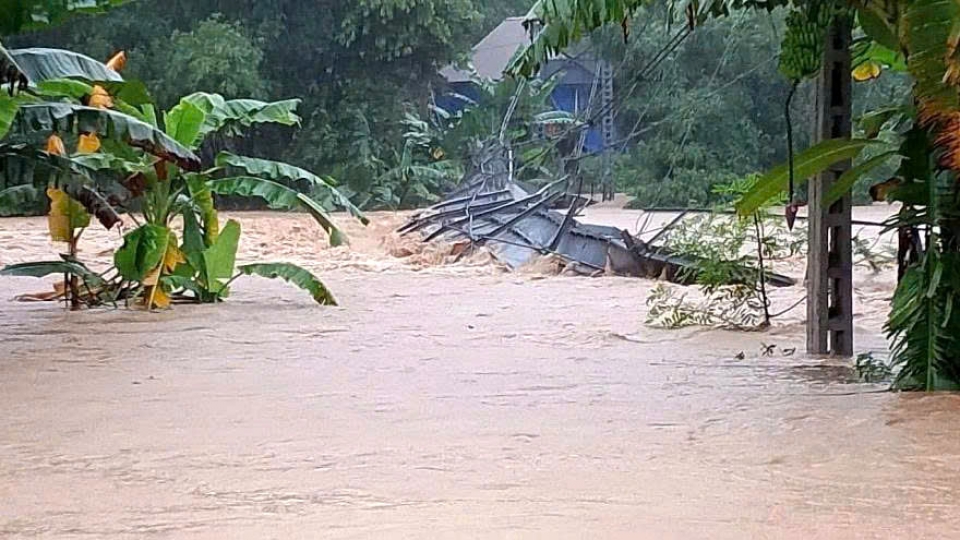
In another development, typhoon Wipha travelled past Vietnam into Laos and dissipated after slamming into the northern and north-central coastal localities from Hai Phong city to Nghe An province on July 22.
According to the Department of Dike Management and Natural Disaster Prevention and Control under the Ministry of Agriculture and Environment, Wipha has caused significant damage, leaving 1 person missing and 1 injured, both in Nghe An province.
More than 400 houses have been damage or lost their roofs; 120,000ha of rice fields have been flooded; and nine livestock animals and nearly 3,300 poultry have been dead or swept away.
Though Wipha was downgraded, it would continue to cause heavy rain across northern and north-central regions on July 24-25. Meteorologists warned that there is a high risk of flash floods on rivers and streams, landslides on steep terrain, and urban flooding in low-lying and riverside areas.
Government urges swift response as Wipha triggers severe flooding in Nghe An
VOV.VN - The Government has urged relevant ministries, agencies, and local authorities to mobilise all available resources to respond to severe flooding in the central region, especially in Nghe An province, in the wake of Typhoon Wipha, with a focus on the safety of local people and critical infrastructure.


