Government urges swift response as Wipha triggers severe flooding in Nghe An

VOV.VN - The Government has urged relevant ministries, agencies, and local authorities to mobilise all available resources to respond to severe flooding in the central region, especially in Nghe An province, in the wake of Typhoon Wipha, with a focus on the safety of local people and critical infrastructure.

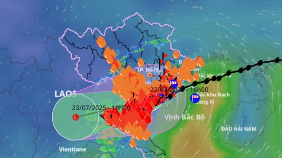
Wipha, after slamming into Vietnam on July 22, has the northern and north-central regions of Vietnam has caused heavy rain in various localities, particularly in Nghe An, with rainfall ranging from 120mm to 200mm, and over 300mm in some locations within a 24-hour period.
Intense rain has also occurred in the upper reaches of the Ca River in Laos, leading to a dramatic surge in water flowing into the Ban Ve Hydropower Reservoir in Nghe An. As of 10:45 PM on July 22, the inflow had reached 10,044 m³/s, well above the design capacity of 7,770 m³/s, posing a risk of exceeding normal reservoir levels by the morning of July 23.
There is a high risk of flash floods, landslides, and severe flooding in low-lying areas, warned the National Centre for Hydro-Meteorological Forecasting.
Amid increasingly complex flood conditions in the Ca River basin, in its dispatch dated July 22, the Prime Minister directed authorities of Nghe An province to implement urgent flood response measures, with priority to be given to protecting human lives and critical infrastructure, especially the Ban Ve Hydropower Reservoir. He asked them to proactively develop and be ready to deploy evacuation plans in case of the worst-case scenarios.
The Ministry of Agriculture and Environment, and the Ministry of Industry and Trade were instructed to closely monitor the situation and coordinate with local authorities to manage flood prevention and ensure the safety of dikes, irrigation systems, and hydropower structures.
The Ministry of National Defence and the Ministry of Public Security were tasked with directing Military Region IV and stationed units to work closely with local authorities. These forces must deploy personnel, vehicles, materials, and equipment to vulnerable areas at risk of structural failures, flash floods, landslides, and deep inundation, to support the population and conduct rescue operations as needed.
VOV.VN has learned Wipha has triggered sudden rises in river and stream water levels across many areas in western Nghe An, leading to severe flooding, cutting off key transport routes, and severely impacting local residents' lives.
Floodwaters rose throughout the night of July 22, causing suspension bridges over the Lam River in Tuong Duong commune to collapse. Many residential areas in the former Thach Giam township were submerged under 1 to 2 meters of water. Several sections along National Highway 7 from Muong Xen commune to Con Cuong commune were impassable due to severe flooding.
Local authorities have placed warning signs at deeply flooded areas and deployed personnel to stand guard at both ends of affected routes to ensure the safety of residents and vehicles.
So far, one person has gone missing and another has been injured due to flooding in Nghe An. Provincial authorities have evacuated 305 households to safe shelter locations.
Typhoon Wipha downgraded, but flood and landslide threats remain
VOV.VN - Typhoon Wipha, Vietnam’s third storm of the year, weakened into a tropical depression on the evening of July 22 after sweeping through northern and north-central provinces, triggering intense rainfall and heightening the risk of flash floods and landslides.


