Super Typhoon Ragasa expected to weaken rapidly before slamming into Vietnam

VOV.VN - Meteorologists forecast that super typhoon Ragasa, currently raging in the East Sea with winds exceeding 200kmh, is likely to weaken before making landfall in Vietnam due to unfavourable conditions.
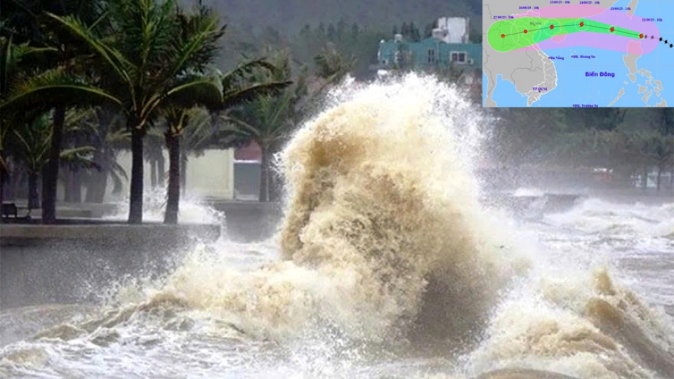
Ragasa entered the East Sea on the evening of September 22, becoming the ninth storm of this year’s rainy and stormy season in the region. It is currently considered the strongest typhoon in the world, with near-center winds reaching 202–220kmh, and gusts even higher.
Although stronger at sea than Typhoon Yagi in 2024, Mai Van Khiem, director of the National Centre for Hydro-Meteorological Forecasting, said at a meeting of the National Civil Defence Steering Committee on September 22 that several factors would cause Ragasa to be downgraded rapidly in the coming days.
“A continental cold air mass is currently moving southward, impacting the northern part of the super typhoon and contributing significantly to its weakening as it passes southern Guangdong and Leizhou Island of China on September 24,” said Khiem.
Ragasa is moving westward but is expected to shift north over the next 2–3 days, encountering friction from China’s landmass. Both international forecasts and AI models tested by Vietnam in collaboration with Japan agree that the typhoon’s path will move north of Leizhou Island rather than south, as Yagi did, leading to more pronounced weakening.
In addition, statistics show that a typhoon typically lasts 5–7 days, peaking in intensity around days 3–4. Ragasa formed on September 18, is currently at its peak stage, and is expected to gradually weaken. Forecasts indicate that by the time it passes the Leizhou Peninsula into the Gulf of Tonkin, the typhoon will reduce its strength, packing winds of 103-139kph.
On land in Quang Ninh to Thanh Hoa provinces, winds may reach 75-88kph, with gusts up to 166kph. Rainfall is expected at 150–250mm, with some areas exceeding 450mm.
“In the scenario that the typhoon moves over Guangdong and then shifts north inland rather than hugging the coast, the strongest winds over the Gulf of Tonkin and Vietnamese land areas will decrease,” said Khiem.
Deputy Minister of Agriculture and Environment Nguyen Hoang Hiep also expressed optimism, stating, “We hope the typhoon behaves as currently forecast. Once entering the East Sea, super typhoon Ragasa is expected to weaken due to unfavourable conditions.”
According to forecasts, by the morning of September 25, Ragasa will be active in the Gulf of Tonkin with near-centre winds of 103–149kmh. It is expected to make landfall around noon or afternoon the same day, with winds of 75–117kmh and gusts of 166kph.
However, this is a 72-hour forecast, so accuracy is limited. The typhoon could intensify or weaken beyond current predictions, and the public is advised to follow subsequent forecasts closely, said the deputy minister.
He urged local authorities to strictly manage boats and ships, and implement temporary sea bans if necessary. Safety measures for aquaculture farms must also be ensured, especially in the Gulf of Tonkin and northern-central coastal areas, which have about 165,000 hectares of aquaculture.
“The biggest concerns are rainfall, safety, and the management of interconnected reservoirs. Currently, reservoirs in northern Vietnam are near full capacity at the end of the main flood season. If extreme rainfall occurs, reservoir operation will be challenging. Irrigation reservoirs are also at 80–90% capacity. Therefore, reservoir operations must follow 48-hour forecasts closely to ensure proper management,” he explained.
Hiep also warned of the potential for thunderstorms before, during, and after the typhoon over both sea and land areas. He advised localities with vessels in the Gulf of Tonkin to monitor forecasts closely to avoid incidents like those recently reported in Ha Long Bay that claimed more than 30 lives.
Regarding agriculture, approximately 810,000 hectares of rice crops may be affected by the typhoon and heavy rain, of which only about 200,000 hectares can be harvested in time. Authorities are urged to prioritise harvesting the most vulnerable crops and prepare drainage solutions and emergency pumping stations for unharvestable areas.
PM orders prompt action to respond to super typhoon Ragasa
VOV.VN - The Prime Minister has requested an early, decisive, and vigilant response, with no room for complacency, and full preparation for the worst-case scenario in order to safeguard the lives and property of the people ahead of super typhoon Ragasa.


