Ragasa moving into East Sea, heading toward North Vietnam

VOV.VN - Super typhoon Ragasa is currently moving into the East Sea and is expected to directly impact northern Vietnam in the coming days, reported the National Centre for Hydro-Meteorological Forecasting of Vietnam.

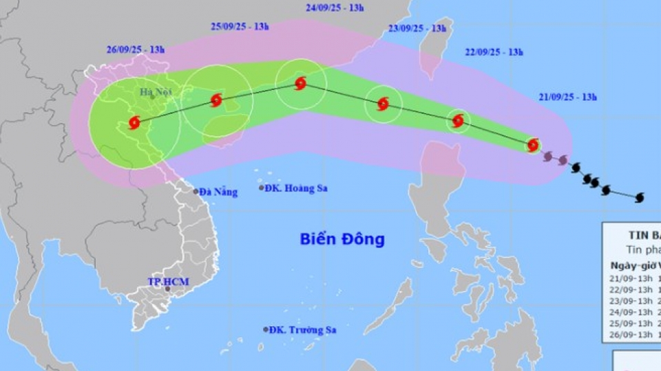
Ragasa is currently located to the east of the Philippines, packing winds of 184-221kph near its centre, and is forecast to enter the East Sea on the evening of September 22 in ‘extensive’ circulation and at ‘relatively high’ speed.
Meteorologists said the super typhoon is anticipated to be at its strongest between September 22–23.
Regional meteorological agencies have all forecast that this is a super typhoon, with wind speeds potentially exceeding 200kmh.
According to the Japan Meteorological Agency, wind speeds could hit 195kmh, with gusts exceeding 200kmh. Chinese forecasts estimate the storm may reach up to 223kmh, while Hong Kong (China)’s Observatory predicts it could intensify to as much as 240kmh.
The National Centre for Hydro-Meteorological Forecasting of Vietnam said there are two possible scenarios for the super typhoon.
In scenario 1, when Ragasa reaches the southern coast of China’s Guangdong Province on September 24, terrain friction may cause it to weaken. It would then move into the Gulf of Tonkin, where it could weaken further by 2–4 categories before approaching Vietnam.
In scenario 2, Ragasa enters the East Sea and follows a more westward and lower trajectory, resulting in less weakening. In this case, the impact of strong winds and high waves in the Gulf of Tonkin would be much greater.
Northern coastal areas of Vietnam, from Thanh Hoa to Hue, would likely experience very strong typhoon winds along with heavy rainfall.
Notably, a cold air mass from the north is currently moving southward. The interaction between this cold air and the super typhoon in the coming days will make Ragasa’s path and intensity more complex.
“These two scenarios differ by just 50–100 km north or south, but the intensity of the storm near Vietnam’s coastline could vary greatly, and so will the resulting impacts. It’s important to stay updated with forecasts based on the latest observational data and analysis,” said Hoang Phuc Lam, deputy director of the National Centre for Hydro-Meteorological Forecasting.
Meteorologists warned that localities at high risk should prepare evacuation plans, especially for coastal regions and flood-prone areas. Residential buildings, trees, and public infrastructure should be inspected and reinforced to withstand strong winds.
Rescue teams and medical services should be ready to respond to any emergency situations.
Since the beginning of the year, the East Sea has experienced 8 typhoons and 2 tropical depressions. The most recent was Typhoon Mitag, which made landfall in China on September 21 and did not directly affect Vietnam.
Typhoon Ragasa enters East Sea, northern Vietnam faces widespread heavy rain
VOV.VN - Typhoon Ragasa is continuing to strengthen and moving quickly into the East Sea, becoming the ninth storm of the year, and is forecast to directly affect northern Vietnam on September 25-26.


