Strong, fast-moving Kajiki expected to make landfall on August 25

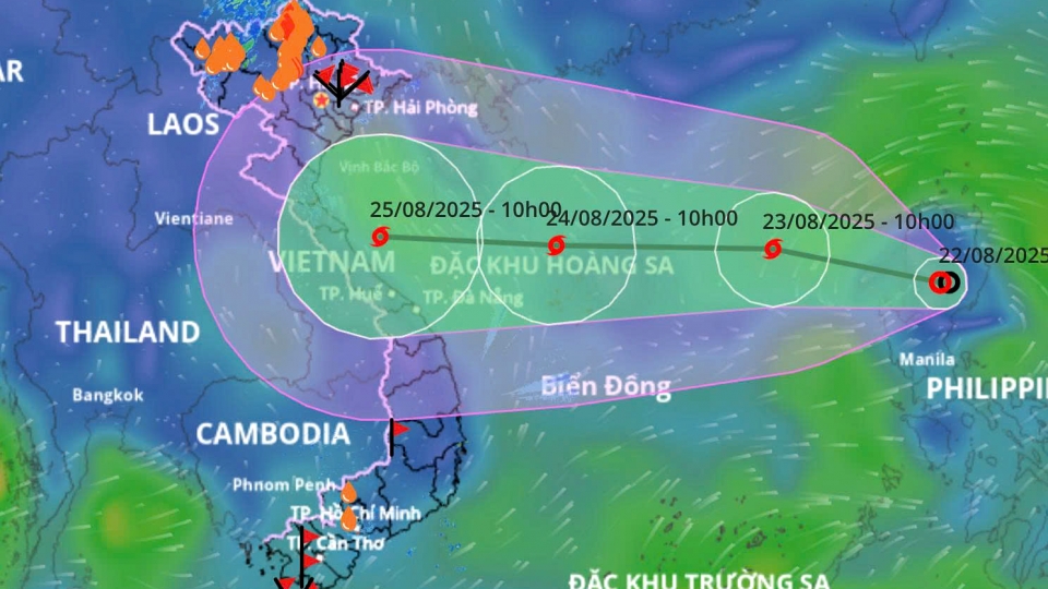
VOV.VN - A tropical depression entered the East Sea on the night of August 22 and quickly strengthened into typhoon Kajiki which is moving rapidly with wide circulation and complex developments, according to the National Centre for Hydro-Meteorological Forecasting.

After moving into the East Sea, Kajiki is anticipated to intensify further in the next 24 hours, packing winds of 89 – 117kph, with gusts up to more than 150kph. Around the early morning of August 25, the typhoon will approach the coastal areas from Nghe An to Thua Thien-Hue, then move inland and gradually weaken.
According to meteorologists, Kajiki is likely to have a wide impact range, affecting northern and north-central provinces, bringing prolonged heavy rainfall, strong winds and high waves, threatening the safety of vessels, coastal structures, and people’s lives.
Due to the storm’s influence, from August 24 the northern and central parts of the East Sea will experience strong winds, with rough seas and tides reaching 4–7 meters high. From Thanh Hoa to Da Nang, beginning on August 25, coastal areas will see storm winds of 89 – 117kph, with gusts up to more than 150kph.
On land, from the night of August 24 until the end of August 27, provinces from Thanh Hoa to Thua Thien-Hue will brace for heavy rain, ranging from 150–300 mm, with some areas exceeding 600 mm.
There is a high risk of flashfloods and landslides in mountainous areas, as well as flooding in low-lying and urban areas. Rivers from Thanh Hoa to Quang Tri are likely to experience a flood wave.
Deputy Minister of Agriculture and Environment Nguyen Hoang Hiep, at a meeting on August 22, requested that local authorities urgently implement storm and flood preparedness plans, review the safety of populations in vulnerable areas, and ensure the safety of reservoirs and flood-prevention works.
Vietnam braces for heavy rain as typhoon Kajiki heads to central coast
VOV.VN - Vietnam’s central region is bracing for the arrival of typhoon Kajiki in the coming days, with authorities closely monitoring its path and preparing for significant impacts.


