Kalmaegi enters East Sea with strong winds, gusts up to 17 (200-220 km/h)

VOV.VN - Early this morning (November 5), typhoon Kalmaegi entered East Sea, becoming the 13th storm of 2025, and is moving rapidly, according to the National Center for Hydro-Meteorological Forecasting.

It is expected to be about 550 km from the coast of Gia Lai province in the Central Highlands by early tomorrow (November 6).
The strongest winds near the storm center are force 13 (134-149 km/h), with gusts up to force 16 (180-199 km/h). The storm is moving northwest at 20-25 km/h.
On November 6, Kalmaegi will continue northwest at about 25 km/h, roughly 550 km east-southeast of Gia Lai coast, and may intensify further, with winds near the center reaching force 14 (150-165 km/h) and gusting up to 17 (200-220 km/h). A high-level natural disaster warning for the central East Sea has been issued, including northern waters of the Spratly Islands.
By 4 a.m. on November 7, Kalmaegi will move northwest at about 25 km/h over land from Quang Ngai to Dak Lak and gradually weaken, with maximum winds near the center gusting to force 12 (118-133 km/h).
Winds in central East Sea, including northern Spratly waters, will reach force 8-11 (62-117 km/h), while areas near the storm path may experience force 12-14 (118-165 km/h), gusting to 17 (200-220 km/h), with sea waves 5-7 m high, reaching 8-10 m near the storm center. Seas will be extremely rough.
From early November 6, winds in coastal waters from Da Nang to Khanh Hoa, including Ly Son, will strengthen from force 6-7 (39-61 km/h) to force 8-11 (62-117 km/h), with areas near the storm path reaching force 12-14 (118-165 km/h), gusting to 17 (200-220 km/h). Waves along the coast from Hue to Dak Lak will be 4-6 m high, reaching 6–8 m near the storm center, with extremely rough seas.
Storm surge along coastal areas from Hue to Dak Lak may reach 0.3-0.6 m, causing local flooding. From late afternoon Nov. 6, coastal areas should be alert for high seas and waves, which may flood low-lying areas, overtop dikes, disrupt coastal roads, erode beaches, and slow drainage. All ships, boats, and aquaculture facilities in these areas will be affected by thunderstorms, tornadoes, strong winds, high waves, and storm surge.
Onshore, from late afternoon Nov. 6, coastal areas from southern Quang Tri to Da Nang and eastern provinces from Quang Ngai to Dak Lak will see winds strengthening from force 6-7 (39-61 km/h) to force 8-9 (62-88 km/h), with areas near the storm center reaching force 10-12 (89-117 km/h), gusting to 14-15 (167-199 km/h). In the evening and night of November 6, western areas from Quang Ngai to Dak Lak will experience winds rising to force 6-7 (39-61 km/h), with areas near the storm center reaching force 8 (62-74 km/h), gusting to 10 (89-102 km/h).
From November 6-7, areas from Da Nang to Dak Lak in the Central Highlands will experience very heavy rainfall, typically 200-400 mm per storm, with localized totals above 600 mm. Areas from southern Quang Tri to Hue, Khanh Hoa, and Lam Dong will have heavy rain, typically 150-300 mm per storm, with localized totals over 450 mm. Rainfall is expected to decrease from November 8.
From November 7-8, northern Quang Tri to Thanh Hoa will see moderate to heavy rain, typically 50-150 mm per storm, with some areas exceeding 200 mm. Heavy rain exceeding 200 mm in three hours may occur.
Due to the broad circulation of Kalmaegi, thunderstorms, tornadoes, and strong gusts are possible both before and during landfall.

Kalmaegi moves quickly into East Sea, cold air intensifies in northern Vietnam
VOV.VN - Typhoon Kalmaegi is moving rapidly westward at about 25 km/h and is expected to enter the East Sea on November 5, according to the National Centre for Hydro-Meteorological Forecasting.
Kalmaegi heads toward East Sea, cold air mass brings chill to northern Vietnam
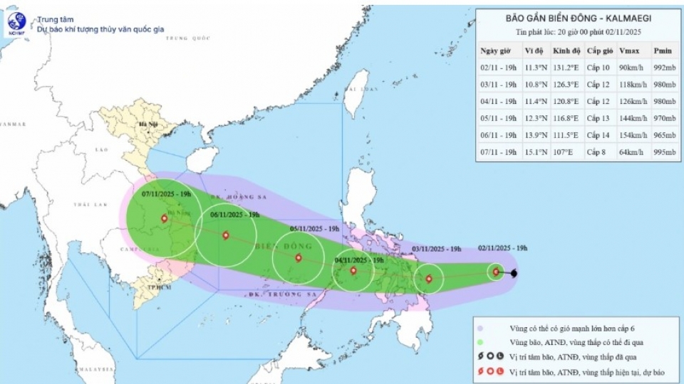
VOV.VN - Typhoon Kalmaegi, the 13th storm to form in the East Sea this year, was moving westward toward the area on the evening of November 2 at a speed of 30-35 kph, according to the National Centre for Hydro-Meteorological Forecasting.
