Kalmaegi moves quickly into East Sea, cold air intensifies in northern Vietnam

VOV.VN - Typhoon Kalmaegi is moving rapidly westward at about 25 km/h and is expected to enter the East Sea on November 5, according to the National Centre for Hydro-Meteorological Forecasting.

With wind gusts exceeding level 17 (over 208 km/h) and waves 8-10 meters high, the sea area from Da Nang city to Khanh Hoa province is warned to be directly affected, with extremely rough waters.
Forecasts indicate that over the next 72-108 hours, the typhoon will move mainly northwestward at 20–25 km/h, gradually weakening in intensity.
From the afternoon of November 4, winds in the eastern central East Sea will strengthen to levels 6-7 (39-61 km/h), then increase to 8-10 (62-102 km/h); near the typhoon’s center, winds will reach levels 11-13 (103-167 km/h), gusting to 15-16 (over 208 km/h), with waves 5.0-7.0 meters high.
All vessels and offshore facilities in the affected area will face strong impacts from storms, whirlwinds, high winds, and large waves.
In other weather developments, on the evening of November 3, cold air affected the entire northern and north-central regions, reaching central-central areas, causing lower temperatures and scattered rain. Winds of levels 6-7 (39-61 km/h), gusting to 8 (62 km/h) were recorded at Bach Long Vi Island.

From now until November 5, northern Vietnam, Thanh Hoa province, and northern Nghe An province will see scattered rain with continued cold. Minimum temperatures generally range from 16-19°C, dropping below 15°C in mountainous areas.
In Hanoi, from now until November 4, rain and cold persist, with temperatures between 17-19°C.
Due to reinforced cold air combined with upper-level easterly disturbances, the area from Ha Tinh to Quang Tri will continue to experience widespread heavy rain, with risks of flash floods, landslides in mountainous areas, and flooding in low-lying regions.
Experts warn that cold weather may affect livestock, poultry, and crops, particularly in northern mountainous areas. Prolonged heavy rain could cause local flooding and disrupt transport, while strong winds and high seas endanger vessels at sea.
Meteorological agencies advise residents to keep warm, protect livestock, and closely monitor weather updates to respond promptly to extreme developments in the coming days.
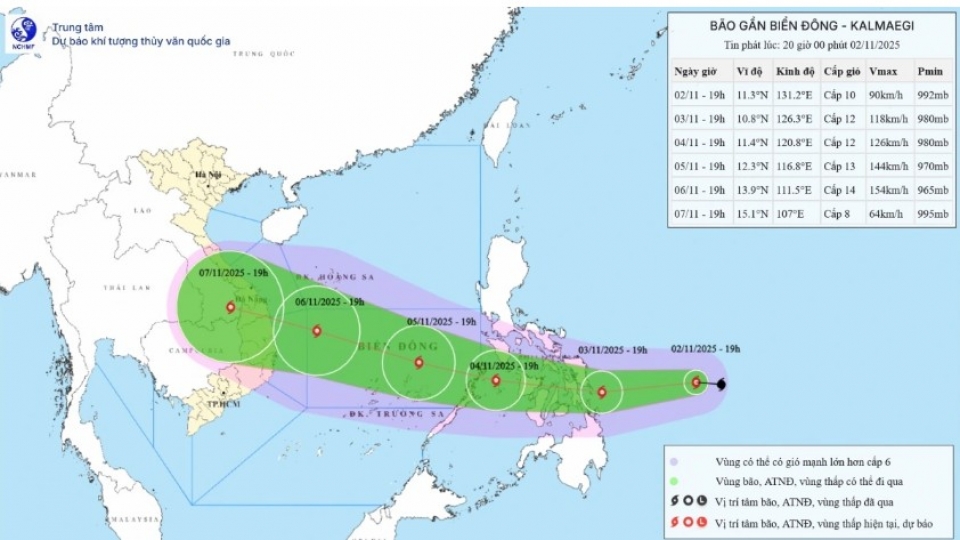
Kalmaegi heads toward East Sea, cold air mass brings chill to northern Vietnam
VOV.VN - Typhoon Kalmaegi, the 13th storm to form in the East Sea this year, was moving westward toward the area on the evening of November 2 at a speed of 30-35 kph, according to the National Centre for Hydro-Meteorological Forecasting.
