Widespread flooding expected across Central Vietnam as Fengshen nears

VOV.VN - Provinces in central Vietnam are expected to brace for widespread flooding when typhoon Fengshen makes landfall in the early morning of October 23, according to the National Centre for Hydro-Meteorological Forecasting.

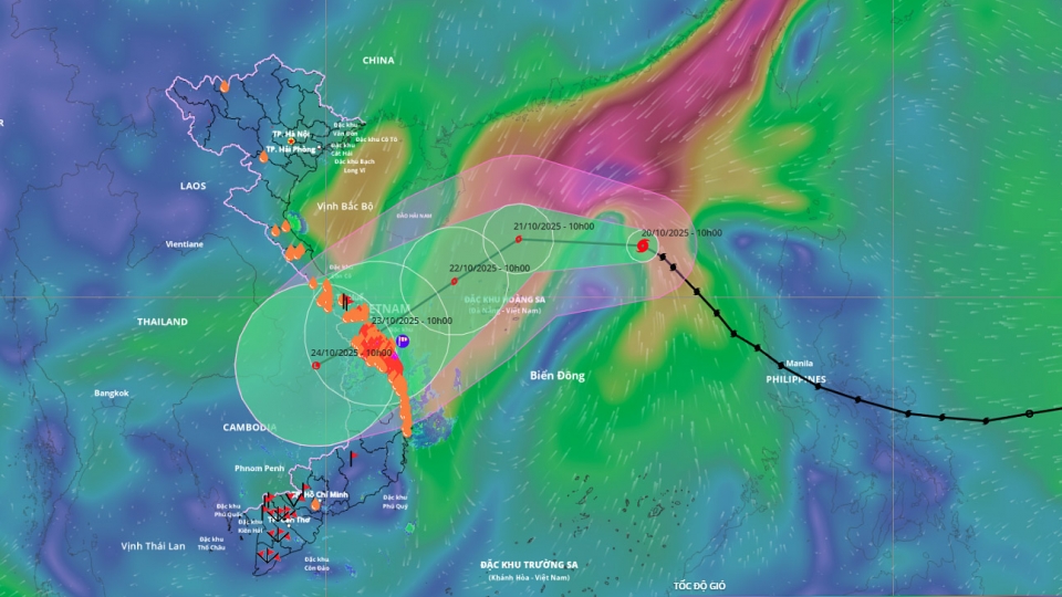
Although Fengshen is forecast to weaken as it comes ashore with winds of 89–102 km/h, it is projected to dump extremely heavy rain, up to 900 mm, on the region stretching from Ha Tinh to Quang Ngai provinces, starting midday October 22.
Meteorological experts have issued a Disaster Risk Level 3 on a scale of 5, signalling significant potential damage. Along the coast from Quang Tri to Da Nang, storm surge of 0.4–0.8 m is expected. All vessels operating in the dangerous sea zones should anticipate thunderstorms, tornadoes, strong winds and high waves.
On land, due to the combined effects of the storm’s circulation, a cold air mass, and topographical effects, coastal localities from Quang Tri to Da Nang will experience increasing winds up to 39–49 km/h, with gusts up to 51-86km/h.
From October 22 to 27, areas from Ha Tinh to Quang Ngai will see heavy, widespread rain. Rainfall is expected to be 200–400 mm in Ha Tinh to north Quang Tri and Quang Ngai, with some places over 500 mm. In the region from southern Quang Tri to Da Nang the general range is 500–700 mm, with isolated spots above 900 mm. Rainfall intensity might exceed 200 mm per 3 hours.
Heavy rain in the central region may continue until late October 2025, creating high risks of flashfloods and landslides in mountainous areas, and inundation in low‑lying and urban zones.
From October 22 to 28, water levels in rivers such as those in Quang Tri and Hue will likely reach alert level III or above. Authorities warn of deep, wide‑area flooding in provinces from Quang Tri to Quang Ngai, along with a high risk of flashfloods in streams and landslides on slopes in those provinces.
Localities are advised to pay attention to safely managing hydroelectric and irrigation reservoirs during and after the storm, and prepare response plans for river floods that may rise to or exceed alert level III.
Typhoon Fengshen changes course, threatens central Vietnam with flooding
VOV.VN - Typhoon Fengshen, currently swirling over the East Sea, is forecast to change direction on October 21 and make landfall between Da Nang and Quang Ngai provinces two days later, raising concerns about heavy flooding in Central Vietnam.


