Typhoon Fengshen changes course, threatens central Vietnam with flooding

VOV.VN - Typhoon Fengshen, currently swirling over the East Sea, is forecast to change direction on October 21 and make landfall between Da Nang and Quang Ngai provinces two days later, raising concerns about heavy flooding in Central Vietnam.

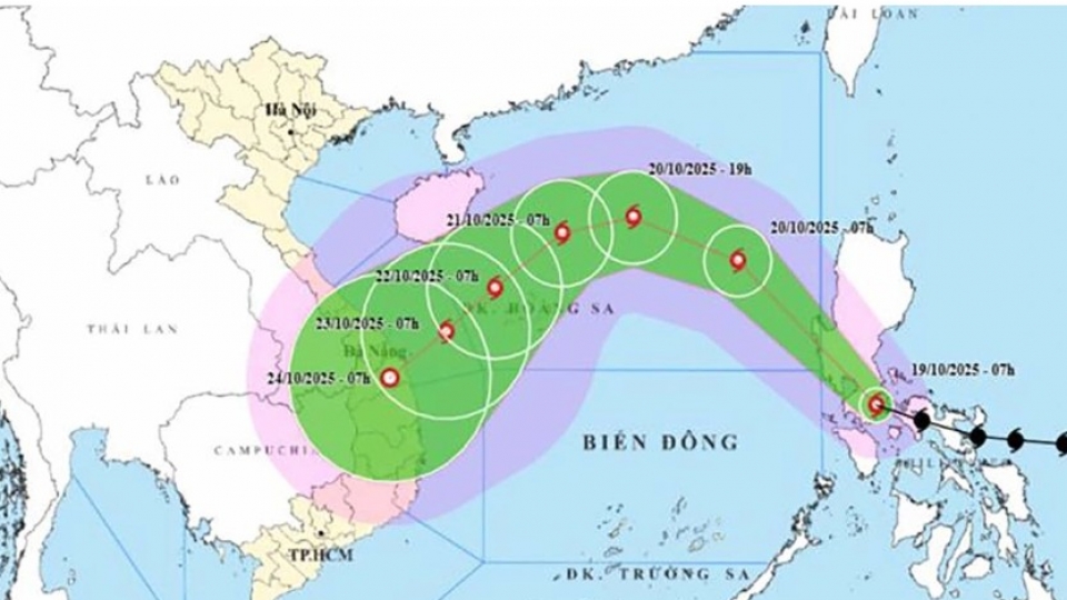
According to the National Centre for Hydro-Meteorological Forecasting, as of 10:00 AM on October 20, Fengshen was located about 460 km east-northeast of the Hoang Sa (Paracel) Archipelago, packing winds of between 75–88 km/h near its centre. It was moving northwest at a speed of 20–25 km/h.
By 10:00 AM on October 21, the typhoon could intensify and then shift westward, slowing down to 15 km/h, with wind speeds reaching 103-149km/h.
Fengshen is projected to weaken 24 hours later before making landfall between Da Nang and Quang Ngai at 10–15 km/h.
In the following 72 to 96 hours, the tropical depression is expected to continue moving southwestward at around 10 km/h, eventually weakening into a low-pressure system.
Meanwhile, a weak cold air mass is currently affecting the northeastern part of Northern Vietnam. Another stronger cold air mass is set to affect other parts of the Northeast and North Central regions between October 20-22, with winds ranging between 6 – 19km/h inland and between 12-29km/h in coastal areas.
Starting the night of October 20, northern and north-central localities will experience cooler nighttime and early morning temperatures, with mountainous areas turning cold. The lowest temperatures during this cold spell are forecast to be around 19–21°C in the Northern Delta and Thanh Hoa province.
From October 22 to 27, due to the combined effects of the storm’s circulation, cold air, easterly wind disturbances, and orographic enhancement, widespread and prolonged heavy rainfall is expected from Ha Tinh to Quang Ngai provinces.
Meteorologists waned there is a high risk of flashfloods and landslides in mountainous areas, as well as flooding in low-lying and urban zones.
Local authorities are advised to ensure the safe operation of hydropower and irrigation reservoirs before, during, and after the storm. Contingency plans should be in place to respond to possible flooding scenarios, with water levels on rivers from Quang Tri to Quang Ngai possibly reaching or exceeding Alert Level III, the highest level.
The disaster risk level due to flooding and inundation has been rated at Level III on a 5-level scale.
Storm Fengshen nears East Sea as northern Vietnam braces for first cold spell
VOV.VN - Tropical Storm Fengshen is moving quickly northwestward and is expected to enter the East Sea on October 20, while a cold spell begins affecting northern Vietnam, bringing cooler nights and early mornings.


