Typhoon Matmo intensifies, forecast to bring heavy rain to six Vietnamese provinces

VOV.VN - Typhoon Matmo strengthened to level 12 winds (118-133 km/h), gusting to level 15 (over 170 km/h), moving west-northwest at about 25 km/h on the afternoon of October 4, and is forecast to hit the northern coast of Vietnam, bringing strong winds, heavy rain and flooding risks to six provinces from Quang Ninh to Hung Yen in the coming days.

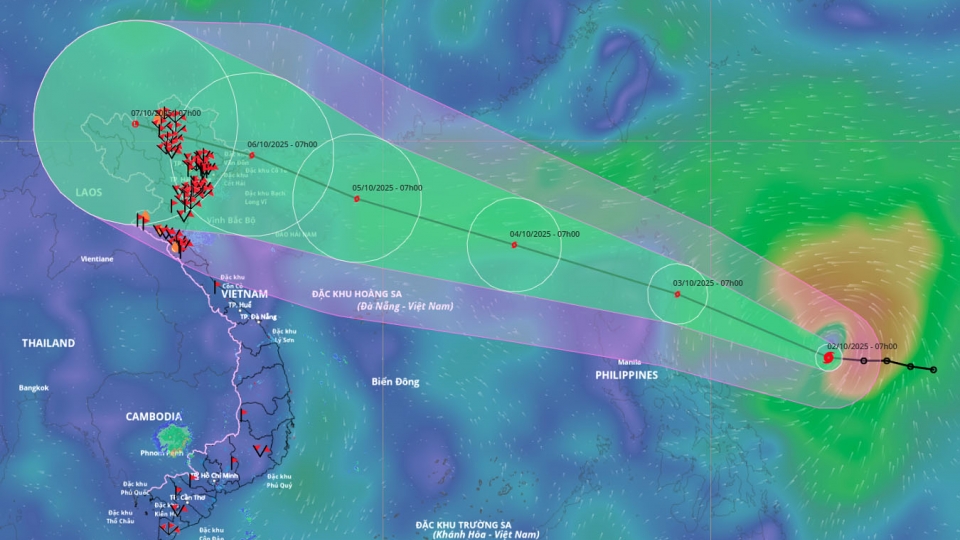
According to the National Centre for Hydro-Meteorological Forecasting, over the next 24-60 hours, the storm is forecast to intensify further before making landfall.
By the afternoon of October 5, Matmo is expected to be near the western part of the Leizhou Peninsula, China, about 250 km east-southeast of Quang Ninh province, with sustained winds of level 12 and gusts to level 15. The dangerous zone extends north of latitude 16.5°N and between longitudes 109°E and 118°E, posing a level 3 natural disaster risk, affecting the northern East Sea.
By early October 6, Matmo is predicted to move into the northern Gulf of Tonkin and weaken to level 9 winds (75-88 km/h), gusting to level 12, with impacts reaching coastal areas from Quang Ninh to Hung Yen, as well as inland northern mountainous provinces. By the afternoon of October 6, the storm will make landfall in northern mountainous areas of Vietnam, weakening to level 6 winds (39-49 km/h), gusting to level 8 (62-74 km/h).
The typhoon is forecast to bring gale-force winds of level 8-10 (62-102 km/h) in the northern East Sea, reaching level 11-13 (103-149 km/h) near the storm’s center, with gusts up to level 16 (≥170 km/h) and waves of 4-6 m (up to 6-8 m near the center), causing extremely rough seas dangerous for all vessels. From the afternoon of October 5, winds will strengthen to level 8-9 (62-117 km/h) in coastal waters including Bach Long Vi, Van Don, Co To, Cat Hai and Hon Dau islands, with wave heights of 2-4 m and gusts up to level 14 (150-165 km/h) in some areas.
From the night of October 5 through October 7, coastal provinces from Quang Ninh to Hung Yen will experience strong winds of level 6-7 (39-61 km/h), rising to level 8-9 (62-117 km/h) near the storm’s path, with gusts up to level 11 (103 km/h). These winds can uproot trees, tear off roofs, and damage buildings. Heavy rains will affect northern Vietnam, with rainfall ranging from 150-250 mm and locally exceeding 400 mm, particularly in Quang Ninh, Cao Bang, Lang Son, Thai Nguyen, northern Tuyen Quang and Lao Cai. In the Red River Delta and Thanh Hoa, rainfall of 70-150 mm is expected, with local peaks over 200 mm.
Hanoi is forecast to experience moderate to heavy rain from early October 6 to the end of October 7, with totals of 70-120 mm and localized peaks over 150 mm. Given the broad circulation of the typhoon, thunderstorms, tornadoes, and strong gusts may occur before and during the storm’s landfall.
Authorities have warned that maritime and coastal areas will be extremely dangerous for all vessels, with high risk of flooding in low-lying coastal and river mouth areas from the afternoon and evening of October 5. Residents and local authorities are urged to take proactive measures to protect lives and property.

Two possible scenarios for Matmo’s impacts on Vietnam
VOV.VN - Assoc. Prof. Dr. Mai Van Khiem, Director of the National Centre for Hydro-Meteorological Forecasting, has outlined two major possible scenarios for Typhoon Matmo’s impacts as it makes landfall in Vietnam, with Quang Ninh, Hai Phong, and Ninh Binh provinces most at risk.
Vietnam braces for new tropical storm - Matmo
VOV.VN - The National Centre for Hydro-Meteorological Forecasting (NCHMF) has issued warnings of heavy rain, strong winds, and high waves as a tropical depression strengthened into a storm early on October 2, with the potential to make landfall in mainland Vietnam.
