Two possible scenarios for Matmo’s impacts on Vietnam
VOV.VN - Assoc. Prof. Dr. Mai Van Khiem, Director of the National Centre for Hydro-Meteorological Forecasting, has outlined two major possible scenarios for Typhoon Matmo’s impacts as it makes landfall in Vietnam, with Quang Ninh, Hai Phong, and Ninh Binh provinces most at risk.

Tropical storm Matmo, the 21st storm in the Northwest Pacific this year, strengthened from a tropical depression on the morning of October 3 and reached the eastern coast of Luzon Island, Philippines, by noon.
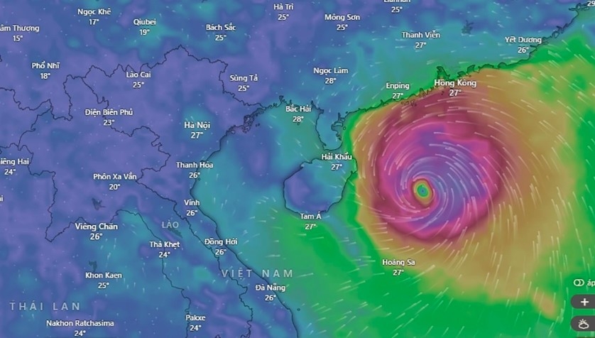
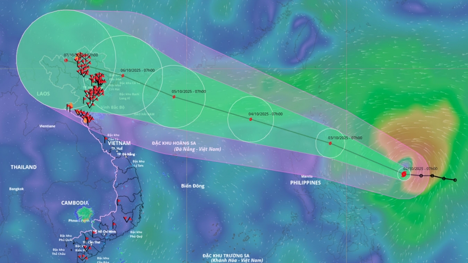
Named by the United States, “Matmo” means heavy rain in Chamorro. Forecasts indicate that by the afternoon of October 3, Matmo will enter the East Sea and, by the afternoon and evening of October 5, pass between Hainan Island and the Leizhou Peninsula, China, before heading toward the northern Gulf of Tonkin.
At that stage, Matmo is expected to weaken from wind speeds of about 89-117 km/h (equivalent to wind levels 12-13) to around 89 km/h (level 10) but may still reach 89-117 km/h with gusts up to 150-166 km/h over sea. Favorable sea surface temperatures of around 29°C and low wind shear in the northern East Sea will support Matmo’s development. Meanwhile, a subtropical high-pressure system steering the storm westward could increase its speed to 25-30 km/h.
From the moment Matmo enters the waters near Guangdong Province, two major scenarios are possible.

In the first and more likely scenario, with a probability of 70-75%, the subtropical high weakens and shifts eastward, causing Matmo to veer more northward and pass over land, similar to Typhoon Ragasa. This path would weaken Matmo by 2-4 wind levels before reaching northern Quang Ninh. Under this scenario, winds in the Gulf of Tonkin would reach 75-88 km/h, with gusts of 62-74 km/h inland in Quang Ninh and Hai Phong, accompanied by heavy rainfall in northern midland and mountainous areas.
In the second, more extreme scenario, with a probability of 25-30%, the subtropical high remains relatively strong, causing Matmo to travel mainly over sea and weaken less. Winds at landfall in Quang Ninh could then reach 75-88 km/h with gusts of 112-135 km/h, extending the impact further south to Ninh Binh, with heavier rainfall and deeper wind penetration inland.
From the night of October 5 to the end of October 7, northern Vietnam and Thanh Hoa province are expected to experience heavy to very heavy rainfall of 100-200 mm, locally exceeding 300 mm. Mountainous and midland areas of northern Vietnam could receive 150-250 mm, with local accumulations above 400 mm.
From October 6-9, a flood wave is forecast in northern Vietnam, Thanh Hoa, and Nghe An provinces, with river levels rising from above warning level 2 to above warning level 3 in some areas.
Meteorological agencies will issue updates on Matmo’s progress, four forecasts daily initially, increasing to eight per day from the afternoon of October 3 when the storm enters the East Sea.


