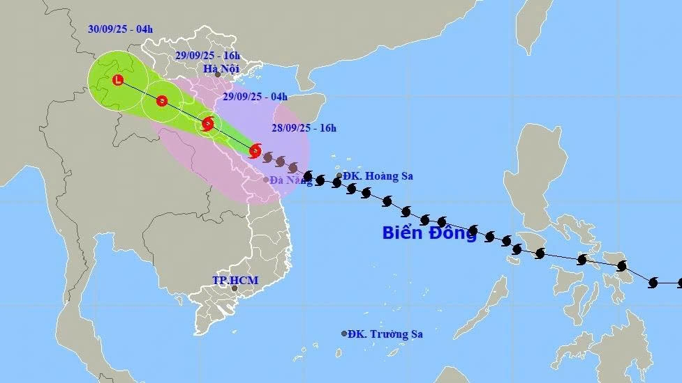
Typhoon Bualoi slams into central coast of Vietnam
VOV.VN - Typhoon Bualoi, packing winds of 118 - 133km/h near its eye, is sweeping across central Vietnam, triggering heavy rainfall and coastal surges of up to 7 m high.

The typhoon is moving west-northwest at a speed of 20–25 km/h. It is forecast to make landfall in the Nghe An–Ha Tinh provinces by 4 a.m. on September 29, with winds weakening to 47–54 km/h.
Bualoi is expected to dump heavy rain on the central provinces, with average accumulations of 200–400 mm and localized totals exceeding 600 mm, particularly in the provinces from Thanh Hoa to Quang Tri.
The meteorological agency has issued a Level 4 out of 5 natural disaster alert, covering warnings of flashfloods, landslides, coastal flooding, and inundation in low-lying areas.
As of 11:00 p.m. on September 28, at least two people have died and four are missing due to the impact of the typhoon. Many areas, including Quang Tri and Da Nang, have experienced strong gusts, causing roofs to be torn off and trees to be uprooted.

The Traffic Police Department under the Ministry of Public Security announced the closure of the North–South Expressway to ensure the safety of people and property during the heights of the typhoon as it makes landfall in Nghe An and Ha Tinh provinces.
Accordingly, the Traffic Police will close the section from Nghi Son Interchange in Thanh Hoa province at section Km380 to Vung Ang Interchange in Ha Tinh province at section Km568+500 from 11:00 p.m. on September 28 to 4:00 a.m. on September 29.
Several provinces in the central region such as Quang Nam, Quang Tri, Ha Tinh, Thanh Hoa and Hue also announced school closures on September 29 for safety reasons.

Typhoon Bualoi, with winds exceeding 130 km/h and heavy rain, has caused widespread power outages across central Vietnam.
In Ha Tinh province alone, the Ha Tinh Power Company reported that as of 9:30 p.m. on September 28, a total of 347,679 customers were without electricity, accounting for 71% of the province’s total customers.
Power outages affected 42 communes and wards, including the loss of electricity at many local administrative centres. Ha Tinh’s power sector is urgently mobilising péonnel, closely monitoring the storm’s developments, and planning to restore electricity as soon as conditions allow.

According to Hoang Phuc Lam, deputy director of the National Centre for Hydro-Meteorological Forecasting, the eye of typhoon Bualoi is expected to make landfall around 1 a.m. on September 29, with the peak of strong winds and heavy rainfall occurring between 4-5 a.m., marking the most dangerous phase of the typhoon.
The core area directly affected by the typhoon stretches from Thanh Hoa to Quang Tri provinces. This area has been placed under a Level 4 disaster risk alert due to the potential for extremely strong winds and heavy rainfall exceeding 200mm within 3 hours.
Lam warned that such strong winds could cause widespread tree falls, damage houses and topple power poles, leading to significant losses. Intense rainfall may result in urban flooding, submerged roads in low-lying areas, flashfloods, and landslides in mountainous regions.
After making landfall, the typhoon is forecast to move further inland into Laos, gradually weakening into a tropical depression.


