Tropical depression near East Sea forecast to strengthen into storm
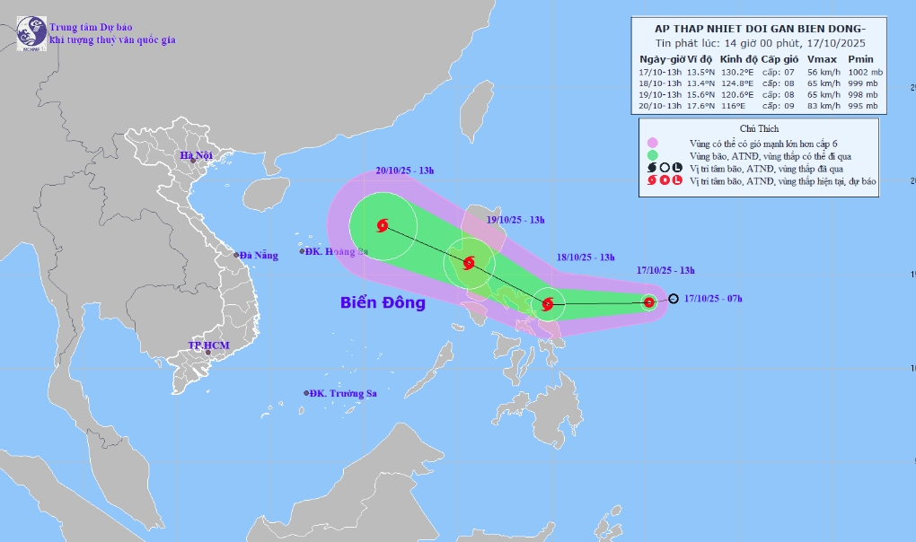
VOV.VN - A tropical depression is forming east of the central Philippines and is expected to strengthen into a storm within the next 24-48 hours, according to the National Center for Hydro-Meteorological Forecasting (NCHMF).
As of October 17, the system was located about 400 km east of the central Philippines, packing maximum sustained winds of level 6 (39-49 km/h) and gusts of level 8 (62-74 km/h).
Over the next 24 to 48 hours, it is forecast to move mainly westward at a speed of 20-25 km/h. By 1 p.m. on October 18, the tropical depression is expected to intensify into a storm with maximum sustained winds of level 8 (62-74 km/h) and gusts of level 10 (89-102 km/h).
By 1 p.m. on October 19, the storm is likely to move west-northwestward, maintaining the same speed and crossing Luzon Island (the Philippines) while keeping its intensity at level 8, gusting level 10.
On land, the outer circulation of the tropical depression may bring scattered showers and thunderstorms to central and southern Vietnam in the coming days, with some areas seeing moderate to heavy rain. Stronger winds are also expected over the eastern and northern parts of the East Sea.
Authorities have advised vessels operating in the East Sea to stay updated on the storm’s movement, avoid dangerous areas, and take safety precautions.
The National Center for Hydro-Meteorological Forecasting expects about three more storms or tropical depressions to form in the East Sea by year’s end, with one or two possibly affecting mainland Vietnam.
So far this year, the East Sea has seen 11 storms and four tropical depressions. Notably, typhoons Wutip, Wipha, Kajiki, Nongfa, Ragasa, Bualoi, and Matmo have either directly hit or caused heavy rain and flooding in the northern and central regions.


