Tropical depression forecast to strengthen into storm

A tropical depression over the eastern waters of the Philippines has strengthened into Storm Wipha early on July 18, according to the National Centre for Hydro-Meteorological Forecasting.

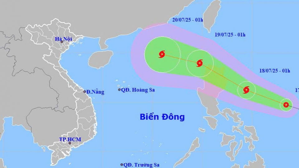
As of 1am on July 18, the storm’s centre was located at approximately 16.4 degree North latitude and 125.3 degree East longitude, over the eastern waters of Luzon Island (the Philippines). Maximum sustained winds near the centre reached between 62–74 kph. The storm was moving northwest at around 20kph.
By 1am on July 19, Wipha is expected to continue northwestward over the northern waters of Luzon, maintaining a speed of 20kph and likely gaining strength, with winds of 62-88kph and gusts reaching level 103-117kph.
By 1am on July 20, the storm is forecast to move west-northwest at 20–25 kph, located about 740km southeast of China’s Leizhou Peninsula. It is expected to enter the East Sea (internationally known as the South China Sea) and further intensify, with sustained winds reaching 89-102kph. The northeastern area of the northern East Sea will be affected. The current disaster risk level is rated at Level 3.
By 1am on July 21, the storm will continue moving west-northwest, about 220 km east of the Leizhou Peninsula, with sustained winds expected to increase to 103-117kph. The affected area remains the northern part of the northern East Sea, with disaster risk still at Level 3.
In the following 72 to 120 hours, Wipha is forecast to continue moving west-northwest at a steady speed of around 20 kph.
Due to the storm’s influence, from the afternoon of July 18, the eastern part of the northern East Sea will see strong winds. Sea waves are expected to reach heights of 2.5 to 3.5m, with rough seas and hazardous conditions for marine traffic, including thunderstorms, squalls, and large waves.
In response, the Ministry of Agriculture and Environment has urged localities and relevant ministries to closely monitor the storm’s developments, strictly manage vessels going out to sea, and promptly notify ship owners and captains about the system’s location and trajectory to avoid entering dangerous areas.
Authorities are also advised to review and implement safety measures for ports, tourism areas, aquaculture farms, and coastal zones.
Proactive plans should be in place to safeguard homes, warehouses, public buildings, industrial zones, factories, power and telecommunications systems, agricultural production, and flood-prone areas in urban and industrial zones.
Tropical depression to strengthen into typhoon on July 18, keep gathering force
VOV.VN - A tropical depression off the coast of the Philippines is forecast to move quickly, strengthen into a typhoon, and enter the East Sea by the night of July 18, according to the National Centre for Hydro-Meteorological Forecasting Centre (NCHMF).
