Storm Koto moves rapidly toward East Sea
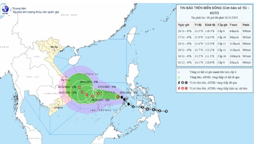
VOV.VN - On the morning of November 26, the center of storm Koto (known in Vietnam as storm No. 15) was located at approximately 12.3°N latitude and 118.3°E longitude, about 440 km east of Song Tu Tay island.

Maximum sustained winds near the storm’s center reached level 8 (62-74 km/h), with gusts up to force 10 (89-102 km/h). The storm was moving northwest at around 25 km/h, according to the National Centre for Hydro-Meteorological Forecasting.
Forecast for the next 24-48 hours
By 7 a.m. on November 27, the storm is expected to enter the central East Sea, roughly 200 km north-northeast of Song Tu Tay Island. At that time, it could strengthen to force 10 winds (89-102 km/h), with gusts up to force 13 (117-149 km/h), and turn gradually west-northwest at 15-20 km/h.
By 7 a.m. on November 28, the storm’s center is forecast at 12.4°N, 113.5°E, about 150 km north-northwest of Song Tu Tay. Its intensity may rise to force 11 winds (103-117 km/h), gusting to force 14 (150-165 km/h), and shift its path west-southwest at 5-10 km/h.
By the morning of November 29, Storm Koto is expected to slow down, located roughly 250 km west-northwest of Song Tu Tay, maintaining force 11 winds (103-117 km/h), gusting to force 14 (150-165 km/h). Between 72 and 120 hours thereafter, the storm is likely to move northwest at around 5 km/h while gradually weakening.
Impact on the East Sea and coastal areas
Due to the storm’s circulation and an influx of cold air, the northern East Sea (including the Paracel Islands) has experienced northeast winds at force 7 (50-61 km/h), gusting to level 9 (75-88 km/h). Bach Long Vi station recorded force 7 winds, gusting to force 9; Con Co, Ly Son, and Con Dao stations reported gusts at force 7; Phu Quy saw gusts up to force 8-9 (62-88 km/h).
In the central East Sea, particularly near the northern Spratly Islands, winds reached force 6-7 (39-61 km/h), with gusts of force 8-10 (62-117 km/h) near the storm’s center. Sea waves are 4-6 m high, potentially 6-8 m near the center, with very rough conditions.
Between November 27-28, the area is expected to experience the strongest impact, with winds possibly reaching level 11 (103-117 km/h), gusting to force 14 (150-165 km/h), and waves rising to 7-9 m, causing extremely rough seas.


