Nongfa weakens into tropical depression, brings heavy rain to north central Vietnam
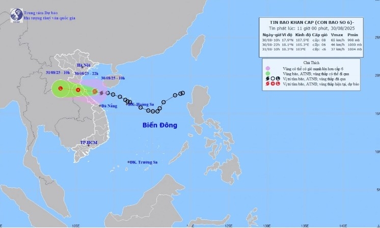
VOV.VN - After making landfall in Ha Tinh and Quang Tri provionces, Typhoon Nongfa (Typhoon No. 6) in Vietnam this year, has weakened into a tropical depression as of the afternoon of August 30, the National Center for Hydro-Meteorological Forecasting reported.
Provinces from Nghe An to Da Nang experienced heavy rainfall, with some localized areas receiving more than 300mm of rain.
The tropical depression is forecast to move west-northwest at a speed of 20 km/h by 4 a.m. on August 31, further weakening into a low-pressure area. The National Center has issued a level-3 natural disaster risk warning for the sea area from southern Nghe An to northern Quang Tri, including Hon Ngu and Con Co islands.
Earlier, the strongest winds from Typhoon Nongfa were expected from the afternoon to evening of August 30, while heavy rainfall was forecast to concentrate in the north-central region from now until the end of August 31.
Typhoon Nongfa is moving quickly. Although it intensified from a tropical depression only on the morning of August 30, landfall is imminent.
Nguyen Van Huong, Head of the Weather Forecast Department at the National Center for Hydro-Meteorological Forecasting, has issued notable warnings regarding this storm.
As of early afternoon on August 30, the typhoon’s center was located off the coastal area of Ha Tinh and Quang Tri. The strongest winds near the typhoon’s eye reached level 8 (62-74 km/h), with gusts up to level 10-11. The storm is moving westward at a speed of 20-25 km/h.
Forecasts indicate that by late afternoon and evening on August 30, the typhoon’s center will move inland from southern Ha Tinh to northern Quang Tri, with winds reaching level 6-7, and up to level 8 near the eye.
Regarding strong winds, the area from southern Ha Tinh to northern Quang Tri will experience the strongest effects of Typhoon No. 6, with sustained winds of level 6-7 and gusts up to level 8.

Provinces from Thanh Hoa to Quang Tri will bear the brunt of heavy rainfall, with total accumulation throughout the storm ranging 200-400 mm, and locally exceeding 600 mm. From now until the end of August 31, this area will continue to receive heavy rain, with rainfall generally 150-250 mm, locally exceeding 350 mm.
Since the morning of August 30, Quang Tri province has seen prolonged heavy rain, especially in border communes of Huong Hoa, Dakrong, Minh Hoa, and Tuyen Hoa. Many areas have been deeply flooded, with rising waters cutting off dozens of inter-village and inter-commune roads.
Later, the rain will spread to the midland and Red River Delta regions from the evening and night of August 30 until the end of August 31, with total rainfall of 50-120 mm, locally over 200 mm.
By 10 a.m. on August 31, the typhoon will continue moving west-northwest at 20 km/h into central Laos, weakening into a low-pressure area (below level 6).


