Localities, ministries urged to gear up for typhoon Melor
Wednesday, 08:58, 16/12/2015
The Central Steering Committee for Flood and Storm Control on December 15 asked authorities of coastal localities from central Da Nang city to southern Ca Mau province, and relevant ministries to brace for tropical storm Melor.
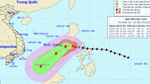
In a notice sent to its sub-committees in these localities and other ministries, the Steering Committee said the storm was centred at 13.2 degrees north latitude and 121.2 degrees east longitude in the central Philippines at 4 pm on December 15.
The storm is forecast to enter the East Sea on the night of December 15 after traversing the central Philippines.
At 13 pm on December 16, the storm will be spotted at about 13.1 degrees north latitude and 119.3 degrees east longitude, about 570 km east-northeast of Song Tu Tay island of Vietnam’s Truong Sa (Spratly) archipelago.
The Steering Committee asked the localities and the Ministries of Agriculture and Rural Development, National Defence, Transport and Foreign Affairs to keep a close watch on the typhoon’s course.
They were requested to steer ships operating at sea to escape from or not to enter dangerous areas, which will cross from the 15th to 5th parallel in the next 72 hours, while informing locals and soldiers on Truong Sa’s islands to take countermeasures.
The committee also called for the close management over vessels going out to sea and regular contact with them, as well as the readiness of relief forces and equipment.
According to the Philippines’ National Disaster Risk Reduction and Management Council, typhoon Melor that swept through the central Philippines on December 15 killed at least three and leaving millions without power.
The tropical storm uprooted trees and cut off electricity supply in at least seven central provinces.
Melor brushed the Bicol peninsula – home to 5.4 million people – on the night of December 14 before slamming into the Romblon island the next morning.
The storm is forecast to enter the East Sea on the night of December 15 after traversing the central Philippines.
At 13 pm on December 16, the storm will be spotted at about 13.1 degrees north latitude and 119.3 degrees east longitude, about 570 km east-northeast of Song Tu Tay island of Vietnam’s Truong Sa (Spratly) archipelago.
 |
They were requested to steer ships operating at sea to escape from or not to enter dangerous areas, which will cross from the 15th to 5th parallel in the next 72 hours, while informing locals and soldiers on Truong Sa’s islands to take countermeasures.
The committee also called for the close management over vessels going out to sea and regular contact with them, as well as the readiness of relief forces and equipment.
According to the Philippines’ National Disaster Risk Reduction and Management Council, typhoon Melor that swept through the central Philippines on December 15 killed at least three and leaving millions without power.
The tropical storm uprooted trees and cut off electricity supply in at least seven central provinces.
Melor brushed the Bicol peninsula – home to 5.4 million people – on the night of December 14 before slamming into the Romblon island the next morning.
