Bualoi strengthens before landfall, heavy rain forecast along central coast

VOV.VN - Typhoon Bualoi is rapidly intensifying as it heads toward central Vietnam, bringing heavy rain across coastal provinces from September 28 to 30, according to the National Centre for Hydro-Meteorological Forecasting.

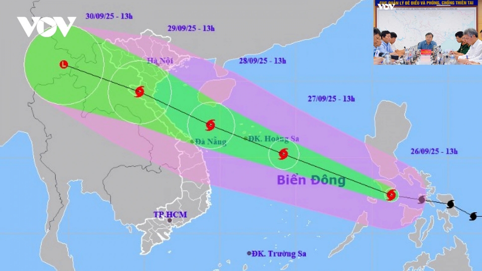
At 7:00 a.m. on September 27, the typhoon was located about 480 km east-southeast of the Hoang Sa (Paracel) Islands of Vietnam, packing maximum sustained winds of 103–133 km/h. It was moving west-northwest at 30–35 km/h, nearly twice the average speed of typical storms in the region.
In the next 24 - 36 hours, Bualoi is expected to strengthen further and make landfall late September 28 through early September 29, affecting areas from Thanh Hoa to Quang Tri provinces, before weakening into a tropical depression over northern Laos.
In response to the typhoon, north-central provinces, including Nghe An, Thanh Hoa, and Ha Tinh, have issued fishing bans, while authorities are mobilizing resources to warn and guide vessels out of danger zones to safe shelters.
Coastal localities are preparing preventive measures to minimise damage and ensure the safety of residents and property.
From the night of September 27 through September 30, heavy to very heavy rainfall is forecast across northern Vietnam and provinces from Thanh Hoa to Thua Thien Hue, with total rainfall of 100–300 mm, and localized areas exceeding 400 mm.
In the Red River Delta and from Thanh Hoa to Quang Tri, rainfall could reach 200–400 mm, with some places expected to receive over 600 mm.
Typhoon Bualoi poses a highly dangerous threat with its rapid movement, strong intensity, and wide impact zone. It is likely to bring a combination of severe hazards, including strong winds, torrential rains, flash floods, landslides, and coastal inundation, warned meteorologists.
Vietnam issues warning as Bualoi approaches North-central region
VOV.VN - The Ministry of Agriculture and Environment held an emergency meeting on September 26 with relevant ministries and local authorities to implement urgent measures in response to typhoon Bualoi that is moving toward North-central Vietnam.


