Wipha to enter Gulf of Tonkin in hours, localities race against time to brace for impact
VOV.VN - Typhoon Wipha, packing powerful winds and torrential rains, is expected to move into the Gulf of Tonkin on July 21, and strike the northern coastal provinces of Vietnam within the coming hours, according to the National Centre for Hydro-Meteorological Forecasting.

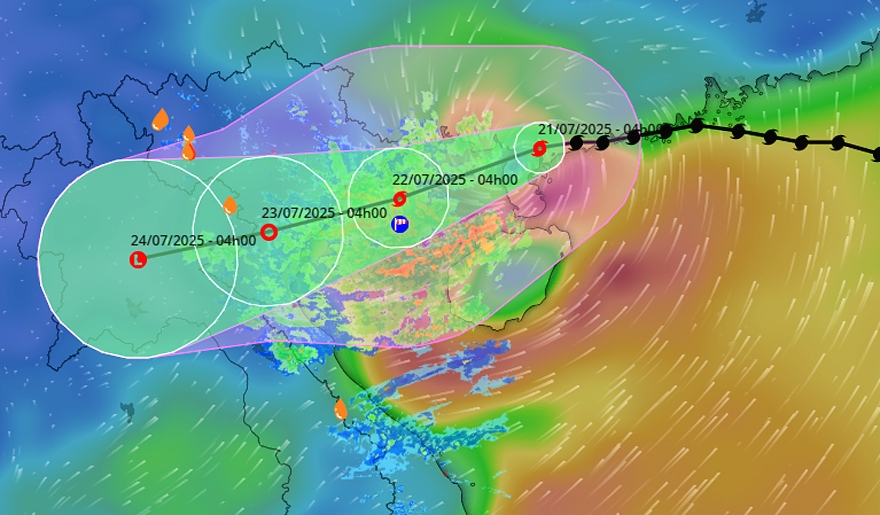
Wipha weakened slightly after moving inland over southwestern Guangdong province, China. At 4:00 a.m. on July 21, the typhoon’s was located over the northern part of the Leizhou Peninsula, about 275km east of Quang Ninh–Hai Phong coast, with winds hitting between 75-88kph near its centre.
In the next 24 hours, the typhoon is expected to slow down, moving at about 15 km/h, crossing the Leizhou Peninsula and entering the Gulf of Tonkin. Due to the warm sea surface temperatures in the Gulf, Wipha may re-intensify, reaching 117kph, with gusts up to 135khp.
Wipha is forecast to make landfall across northern and north-central regions of Vietnam on June 22. As it moves in a west-southwest direction, the landfall zone will shift slightly southward, with the focus on the region stretching from Hung Yen to Thanh Hoa provinces. At the time it nears land, the typhoon may maintain sustained winds of 103-117khp.
By 4:00 a.m. on July 23, as it moves deeper inland over Hung Yen – Thanh Hoa, Wipha will weaken into a tropical depression and then a low-pressure area before gradually dissipating over northern Laos.
Because of the typhoon’s broad and uneven cloud structure, its effects will be widespread, impacting nearly the entire northern and north-central regions of Vietnam, even though the centre is expected to make landfall over the region from Hung Yen to Thanh Hoa provinces.
From July 21 to 23, localities in the northern and north-central regions are forecast to experience heavy to very heavy rain and thunderstorms, with total rainfall commonly ranging from 200–350 mm, and some areas likely exceeding 600 mm.
The meteorological agency has issued a warning of a high risk of extremely intense rainfall, potentially over 150 mm within just 3 hours, which could trigger flash floods and landslides in mountainous areas, as well as flooding in low-lying regions. The typhoon is expected to trigger widespread flooding, landslides, and disruption to transportation and power lines.
As Wipha rapidly approaches, the Prime Minister issued an urgent telegram on July 20, requiring coastal provinces to identify danger zones, reinforce dikes and reservoirs, evacuate residents where needed, and ensure timely public communication.
In response to the order, authorities across coastal provinces are racing against time to evacuate people from vulnerable areas, reinforce critical infrastructure, and secure thousands of boats and coastal homes.
Localities such as Bac Ninh, Hai Phong, Quang Ninh, Thanh Hoa, and Ninh Binh have suspended ferry routes and banned fishing vessels from going to sea starting July 21. They have reviewed and prepared evacuation plans for residents in high-risk areas, including temporary shelter arrangements, food supplies, and essential goods to ensure people’s basic needs are met during the height of the typhoon.
Authorities have intensified inspections and monitoring efforts, strictly handling acts of hoarding, price gouging, and unreasonable price hikes, especially for essential goods such as food, fuel, and other necessities, to ensure supply for residents and businesses before, during, and after the storm.


