Typhoon Wutip nears Hainan, Vietnam braces for heavy rain, severe flooding

VOV.VN - Typhoon Wutip continued to strengthen on the morning of June 13 as it moved toward China’s Hainan Island, posing a high risk of severe flooding, flash floods, and landslides in Vietnam.

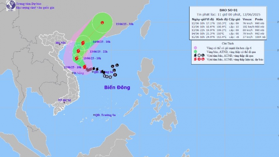
At 4:00 AM on June 13, Wutip was moving near China’s Hainan Island, packing winds of 89 – 102kph, with gusts reaching 133 -149kph. It was moving west-northwest at a speed of around 10kmh.
The typhoon is forecast to shift direction to the north-northeast by June 14 morning, approaching the northeastern part of the Gulf of Tonkin. It is expected to maintain its intensity before weakening into a tropical depression as it makes landfall in China.
Though Wutip is anticipated not to pound Vietnam, its circulation is causing strong winds and rough seas with waves reaching 3 - 6m in the Gulf of Tonkin and coastal waters from Quang Tri to Quang Nam provinces of Vietnam.
Significant rainfall was recorded across the central region on June 12, including 366mm in Bach Ma (Hue), 333mm in Hoa Hiep Bac (Da Nang), and 240mm in Tan Hiep (Quang Nam).
Meanwhile, flooding and landslides were already reported in Quang Ngai, Quang Nam, Hue, and Da Nang. The saturated soil across these areas significantly increased the risk of further landslides.
From June 13 evening onward, coastal areas from Hai Phong city to Nghe An province would face a high risk of flooding due to storm surge combined with high tides.
Heavy rainfall is expected inland, with totals ranging from 50 - 130mm, and even exceeding 250mm in some areas, particularly from Quang Binh to Thua Thien Hue provinces. Moderate to heavy rain and thunderstorms are likely in southern Nghe An, Ha Tinh, Da Nang, Quang Nam, and Kon Tum provinces.
Water levels in rivers across Thua Thien-Hue and Quang Binh provinces are continuing to rise. The Huong River is experiencing a rapid rise in water levels, nearing alert level 2 early on June 13, and further increases are anticipated.
The Vu Gia River in Quang Nam is projected to reach Alert Level 2, indicating a heightened flood threat.
Localities were required to evacuate residents in low-lying areas and near rivers or unstable slopes if floodwaters keep rising. Reservoirs and hydropower facilities should be put under inspection and close monitoring around the clock.
Meteorologists warned about a high risk of flash floods and landslides in mountainous areas of Quang Ngai, Quang Nam, Thua Thien–Hue.
Intensified Wutip to soak Central and Northern Vietnam
VOV.VN - Wutip, the first storm of this year’s typhoon season in the East Sea, has intensified, bringing heavy rain to central and northern regions of Vietnam, according to the National Centre for Hydro-Meteorological Forecasting.


